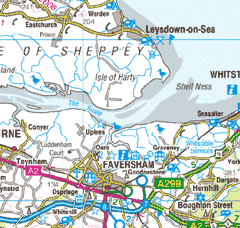
The Swale

Saturday saw a group of eleven paddlers from THCC get out on the Swale estuary in Kent.
The forecast was for quite strong south westerlies with showers and the risk of a thunderstorm. On the whole the location was quite sheltered but we did experience one ferocious squall as we headed back up the estuary to the Harty Ferry Inn on the Isle of Sheppey for lunch. We were paddling into a force 3-4 already and we could see some menacing dark weather coming towards us. All of a sudden the squall was upon us and it was as if a switch had been thrown. The waves quickly grew in size and white crests appeared all around us, we battled ahead straight into the wind barely moving forward, despite some tidal assistance. After about ten minutes the squall passed as quickly as it had arrived and we were rewarded with a hearty lunch!
In the afternoon the sun came out and we explored Oare creek, returning to the very convenient access point at Harty Ferry South just before sunset.